WebUnion Media Limited

Interactive Map Highlight

Visualize Business Sales Data in Europe using Heat Maps

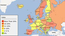
We have developed choropleth mapping in our online map editor to help creating heat maps. Import data from your data source such as Excel files is possible. Color gradient would be generated to highlight trends and distributions over geographical areas.


Cloud Based Mapping Solution

Access from anywhere to view or edit maps online.
Able to locate addresses or build street level maps.
Import or export data efficiently.

Try Online Learn More


Mapping Software

Software with ready made vector maps of almost all countries.
Generate geographical heat map for data visualization.
Color or label a map for presentation on the web.

Download Learn More


Interactive Image Creator

Turn your static image into an interactive element for web.
Highlight areas or draw routes on your plan.
Software produce cross device output, mobile ready.

Download Learn More


Website Building Solution

Create website and customize the design using our software.
Expertise in database and management system setup.
Provide custom made web projects upon demand.

Download Learn More

Back To Top